Accurate wind resource assessment is the financial and engineering foundation of any successful offshore wind project. While European markets have traditionally relied on floating lidar systems (FLS) mounted on autonomous buoys, structural design requirements are driving a critical shift toward technologies that can capture precise turbulence intensity data over multi-kilometre distances.
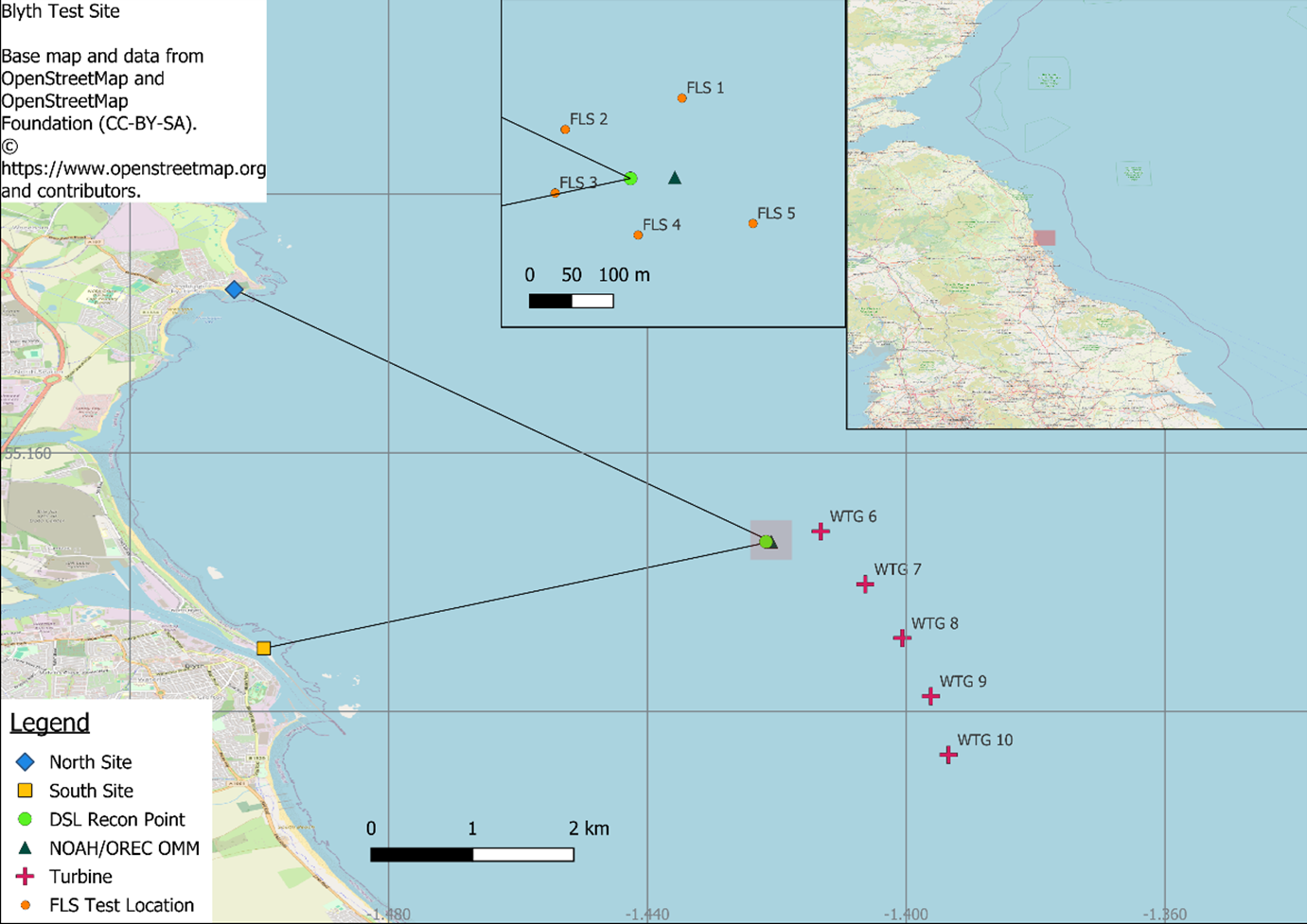
To prove that remote sensing can meet these rigid engineering standards, data from the recent NEMO project at the C-TEST facility near Newcastle, UK, has successfully validated a powerful alternative: Dual-scanning lidar (DSL).
Developed through a joint campaign by Fraunhofer IWES and Oldbaum Services, the testing demonstrates that DSL technology can deliver highly accurate wind speed and turbulence data at distances where traditional systems encounter major operational limits.
The tech leap: blending two beams at sea
The operational principle of dual-scanning lidar relies on intersecting the infrared beams of two long-range scanning devices at a specific measurement point of interest.
- The distance dynamic: Modern DSL systems can accurately profile any location within a 10 to 15 kilometre radius. This makes the technology ideal for coastal project sites or existing offshore wind clusters where scanning units can be safely installed on available turbine transition pieces.
- The turbulence advantage: Unlike floating lidar options, which require complex, dynamic motion-correction software to filter out wave movements, land-anchored or platform-stabilised DSL pairs capture raw turbulence intensity (TI) data directly.
This precise structural calculation is vital. Accurate TI metrics dictate the turbine load forecasting models that safeguard multi-million-pound assets against unexpected mechanical fatigue over decades of operation.
Proving precision at the C-TEST facility
To achieve widespread commercial adoption, new remote sensing techniques must prove their accuracy against a traceable reference. The C-TEST campaign validated a trio of advanced scanning lidars by benchmarking their outputs directly against the National Offshore Anemometry Hub (NOAH) meteorological mast.
The results represent the first publicly verified data of its kind at a range of 6 to 7 kilometres:
- Wind speed accuracy: The wind speed correlation between the coastal DSL units and the offshore met mast matched the precision of on-site floating lidars, aligning perfectly with strict industry acceptance criteria.
- Flawless turbulence capturing: The system tracked turbulence intensity well within a 1% mean bias and a 1.5% representative TI error envelope, proving that the technology is field-ready without requiring backend bias corrections.
Weathering the storm: the ultimate validation
The true test of a wind measurement system is not how it performs during clear skies, but how it behaves during extreme meteorological events.
During the testing campaign, the C-TEST infrastructure was struck by Storm Floris, a major extreme weather event that brought intense wind speeds to the UK coast. The dual-scanning lidar units captured the storm's full life cycle with exceptional detail.
While standard reanalysis datasets considerably underestimated the peak wind vectors of the storm, the DSL tracking data matched the physical cup anemometers on the met mast with a deviation of less than 1.3%. This variance sits comfortably below the baseline uncertainty of the reference mast itself, proving that DSL can survive extreme environments while delivering data that developers can legally bank on.
Driving industry standardisation
The success of the NEMO campaign is accelerating the commercial acceptance of scanning technologies globally. The data gathered at Newcastle is feeding directly into international standardisation efforts, specifically the IEC 61400-50-5 project initiative.
This regulatory push is actively building the consensus technical specifications required to transition dual-scanning lidar from a specialized research option into a globally accepted commercial standard. For forward-thinking developers, the era of relying purely on localized buoys is evolving into a more flexible, connected and multi-kilometre view of the wind.
How is your development team using remote scanning technologies to de-risk turbulence profiling for upcoming offshore campaigns? Share your thoughts in the comments below.
Looking for the full technical breakdown? To read the complete research paper on dual-scanning lidar validation metrics and explore open-access atmospheric datasets, visit the official Fraunhofer IWES website: https://pes.eu.com/exclusive-articles/verifying-dual-scanning-lidar-performance-for-offshore-wind-measurement