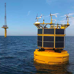
Using tried and tested technology it is possible to save the cost and time of installing offshore met masts by using floating LiDAR systems
Offshore wind resource assessment: floating LiDAR replacing met masts
Initial wind resource assessment is a critical first step to offshore wind development, and the single most important characteristic of a site is its wind speed. The performance of a wind farm is very sensitive to uncertainties and errors in the basic wind speed estimate, therefore the assessment must be extremely accurate in order to secure funding and for the economic development of a wind farm. The traditional solution to measuring local wind conditions is to construct a meteorological mast (met mast) equipped with anemometers and extrapolate those measurements across the length of the wind farm.
Around 7 years ago, floating LiDAR devices emerged as a response to a specific market need. The rising offshore wind industry needed a way to easily gather wind resource data to support the rapid growth in the sector. The traditional met mast method used onshore did not translate well to the marine environment. Onshore, a mast can be erected rapidly at a cost of approximately US$50,000. Offshore, a mast typically takes up to a year to get a permit, around 3 to 6 months to build and incurs a cost of up to US$15 million. In addition, there are significant costs to operate, maintain and decommission met masts. As a result, 25% of UK wind farms have been commissioned or are under construction with less than

